Posts tagged ‘Public Participation’
HydroCity Lecture
November 5, 2009 – 6:30pm
Main Lecture Theatre, UW Architecture Building
Cambridge
The HydroCity Lecture, a Symposium on Hydrology and Urbanism, is presented in conjunction with a Symposium to be held at the University of Toronto on November 6, 2009.
Alan Berger is Associate Professor of Urban Design and Landscape Architecture at Massachusetts Institute of Technology where he teaches courses in the department of urban studies and planning. He founded and directs P-REX, The Project for Reclamation Excellence at MIT, a trans-disciplinary research effort focusing on the design and reuse of waste landscapes worldwide. By using low-angle aerial photography, maps, and other graphic evidence, Berger visually reveals evidence and trends of landscape waste throughout the world—from public health hazards such as abandoned mine pits, mountains of slag, and pools of cyanide, to vacant land, landfills, military installations, and places associated with high and low-density urbanization. How these sites are cleansed, valued and considered for adaptive reuse at local and regional scales is Berger’s main area of interest. His work emphasizes the link between our consumption of natural resources, and the waste and destruction of landscape, to help us better understand how to proceed with redesigning our wasteful places for future productive uses and more sustainable outcomes. He has coined the term “Systemic Design” to describe the productive integration of disvalued landscapes into our urbanized territories and regional ecologies. Berger currently serves as a consultant to the U.S. Environmental Protection Agency on Brownfield and Superfund site revitalization in the American landscape.
Berger’s award winning books include Drosscape: Wasting Land in Urban America, and Reclaiming the American West (PAPress 2006, 2002 respectively) His other books include Designing the Reclaimed Landscape, published (Taylor & Francis 2008) and Nansha Coastal City: Landscape and Urbanism in the Pearl River Delta (Harvard Design School 2006).
Prior to coming to MIT he was Associate Professor of Landscape Architecture at the Harvard-GSD, 2002-2008. He has been Distinguished Visiting Professor of Landscape Urbanism at Oslo School of Architecture in Norway, and at Aarhus School of Architecture in Denmark. He was Distinguished Visiting Professor of Sustainability at University of Michigan’s Taubman School of Architecture, and Visiting Professor for Landscape Urbanism at Katholike University in Leuven-Belgium. He is a Prince Charitable Trusts Fellow of The American Academy in Rome.
A Call to Design: Dunbar Collective

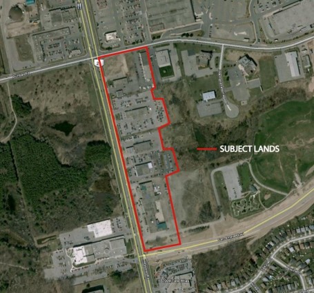
Dunbar Collective: Site Location
I want to ask you the readers if you have a design solution for this location?
I want to create a green technology showcase property for City of Cambridge and hopefully this can be a catalyst project for the rest of Hespeler Road. Maybe this project could be included in the Mayor’s new “green” agenda?!
This project will create some much needed infill and intensification development as well as showcase new technologies through building design, energy systems and sustainability.
Perhaps work towards a LEED certified building(s)?
Site Details
Size: Unknown (I do not have the proper tools at home to calculate it!)
Current Zoning: Commercial, I’m assuming “automotive related”
Potential Zoning: Live/Work units
Transit: iXpress and GRT transit stops already in place at Cambridge Centre Mall, located relatively close to the 401
Other Details:
- More than likely a low-level brownfield site
- Gas station used to be located on corner of Dunbar Road and Hespeler Road
- Several automotive related services were located on properties south of Dunbar, but before the recently closed Galt Chrysler Car Dealership
- “Junky” flea market located at corner of Can-Amera Parkway and Hespeler Road
- YMCA is across the street
- Dumfries Conservation Area located across the street, approximate size of 75 hectares
- New residential towers built at Dunbar and Conestoga Boulevard
- Regional Shopping Centre (Cambridge Centre Mall) located across the street
I’m going to work on drafting some concepts, but I would also love to see your work too!
The Rise of the Student Ghettos
Neighbourhoods around Fanshawe College and the University of Western Ontario are at risk of becoming student ghettos, city planners are warning. The broader plan to improve neighbourhoods around Fanshawe and Western was approved by council in February 2008 and dubbed the near-campus neighbourhoods strategy.
Long-term residents are fleeing, leaving some streets almost entirely occupied by students and other temporary inhabitants who don’t own the homes, a change that threatens the viability of everything from local day cares to churches. The change in ownership has driven up prices of homes whose value are based on rental income, making it tougher for families to buy them. Too many properties have lost green spaces, are in poor repair and become the target of vandals. Previous efforts by city hall to limit changes have sometimes been quashed by provincial appointees on the Ontario Municipal Board.
City planners laid out proposals they hope would make a difference:
- Reduce the maximum number of bedrooms in rental homes to three from five.
- Require outdoor areas that can be enjoyed that are no less than three metres wide in any direction.
- Require proponents of new single and semi-detached homes and those who want to add bedrooms to existing buildings to have their detailed plans subjected to scrutiny at city hall.
Source: LFPress.com
Help Shape the Future of London’s Transportation Plan

The City of London officially launched Smart Moves, its London 2030 Transportation Master Plan study, Monday (Sept. 28), and is looking for Londoners' input into the study.
The next grand plan for transportation in London seems likely to be a greener one, with cyclists, pedestrians and transit riders relegated to the back of the bus.
- A four-line streetcar route shaped like a cross, with downtown London in the centre and the arms reaching north, south, east and west.
- Two rectangles of bus routes intersecting those streetcar lines. GO trains heading east and west, and light rapid transit rail heading to smaller centres.
- All along the routes, people-friendly streets with commercial, retail and residential development built at key connections.
- Instead of buses and streetcars being an afterthought to development, the transit system would actually determine where and how the city grows.
An ambitious plan that turns the idea of London’s transit system on its head.
London Transit unveiled the centerpiece in a push to get feedback on transportation, a city bus covered with the pictures and words of what city officials have dubbed “Smart Moves: What Moves You?” The City of London Smart Moves Transportation Master Plan study, which takes place over the next year, is intended to address future transportation needs of London.
A public meeting has been set and the following information has been provided:
When:
- Tuesday, November 10
Where:
- Western Fair Grounds – Carousel Room
Time:
- 6 p.m. to 7 p.m. Open House
- 7 p.m. to 9:30 p.m. Workshop
Sources: What Moves You?, LFPress.com & LondonTopic.ca
Another Subdivision for Hespeler? PLEASE, “SAY IT AIN’T SO!”

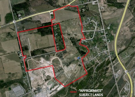
Approximate location of proposed subdivision
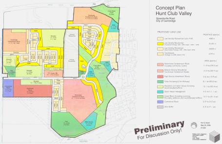
Representatives of Hunt Club Valley Inc. were back before the general committee with a proposed subdivision plan that would transform the east part of the Hespeler area –between Speedsville Road and Beaverdale Road, south from Briardean Road to the Speed River –into a sprawling 1,982 home subdivision… Joy!
While the concept plan itself is not terrible, the fact that area is expanding is what gets me angered. The Region has a Growth Plan in place, which should be followed and recognized. The plan requires “a minimum of 40% of all new residential units must be built within the Built Boundary.” (Warning: pdf format) It will be interesting to see how sewage and water would be implemented in the area considering that the Hespeler and Preston sewage treatment plants are working at near capacity and much of the remaining capacity has already been allotted.

Concept proposal of the subdivision plan.
Last December, council voted to close the file on an earlier application by Hunt Club Valley Inc., because a number of outstanding studies hadn’t been completed. They said they would have those studies completed by January 2009, but the company finally made it to the general committee for Monday September 28’s night meeting. They were trying to push for amendments to the city’s official plan and zoning bylaw.
Almost 20 years ago, Hunt Club Valley Inc. launched the first two phases the Idyllwild Estates off Beaverdale Road, an upscale development with large homes on quarter-acre lots that weren’t connected to the city’s water or sewer services. About 10 years ago ,as the second phase of Idyllwild Estates was being sold out, plans were revised. Hunt Club Valley proposed to change the nature of future development with an urban residential development, which included a broad mix of housing all hooked into municipal services. Those plans were put on hold as various subwatershed and community studies were completed. Now those plans are being modified and reintroduced.
Hunt Club’s planner, Walter Hugo, said his clients are prepared to host a meeting. Hugo said a number of key studies have already been completed. He also stated that if the application is denied, the matter would go to the OMB. A date for the neighbourhood meeting has yet to be set. Meanwhile, a plan is being reviewed by city staff and outside agencies, prior to a recommendation being made to council.
Source: CambridgeTimes.ca
De-Railing Light Transit?

An example of a LRT station.
The iXpress bus service is great already, but LRT would work much better in the case of Waterloo Region. Faster service, dedicated lanes, improved pedestrian connections, and new development construction are just a few of the benefits, oh my!

Current iXpress bus route through Waterloo Region
While Regional council gave formal approval of the LRT plan at the end of June that would bring electric trains to a new Kitchener-Waterloo rail corridor, it meant that Cambridge would be linked in a regional transit system by a fast bus service instead. Lucky Cambridgites… is that what we’re called? Ew!
The local grassroots movement is based in Waterloo and is was formed to express concern about the Region of Waterloo’s planned Light Rail Transit. The group’s other objective is to promote positive ideas for better transit planning in Waterloo Region.
I personally disagree with T4ST and would love to see LRT and BRT systems enacted in the Region. People are crying that there will be low ridership, but how will one know if one does not build? Oh I know how we can fix this idea! Perhaps Waterloo Region’s Growth Plan (warning: pdf format) would like to comment? Yes, I think that would be a fine idea!
The Growth Plan requires that by the year 2015, and each year after, a minimum of 40% of all new residential units must be built within the Built Boundary. The Regional Land Budget assumes a regional intensification rate of 45% by the year 2015, and each year after, thereby allowing for both slightly lower densities within the designated greenfield areas and a larger proportion of higher-density developments to be located closer to high frequency transit. The Regional Land Budget assumes a straight line increase in the annual rate of reurbanization that between the rate of intensification experienced in the region in 2006 (29%) and the proposed rate in 2015 (45%). As a result, the average annual re-urbanization rate from 2006 to 2029 would be 42%.
We are in hard economic times, yes? A recession to be exact, yes? The formation of an LRT system will help bring much needed jobs to the Region, furthering a spur in new transit oriented developments (TOD). The Region will be receiving major funding from upper levels of government, but local taxpayers will still be on the hook for millions of operating costs. I think we as taxpayers in the Region can deal with this seeing as how it can benefit all that use it. According to Ruth How can too much development be a bad thing? TODs are great places to create wonderful new development either through intensified housing or commercial projects.
Taking an excerpt from Section 2.1 of the Places to Grow Policy, one can understand why the Region of Waterloo wishes to construct an LRT; “communities will need to grow at transit-supportive densities, with transit-oriented street configurations. Compact urban form and intensification efforts go hand-in-hand with more transit: not only do they support each other, they are all necessary.” It’s not only what the Provincial government would like to see happen, but also what many residents of the Region would like as well.
Many areas would start to see fresh new ideas popping up, and help develop new partnerships within in the community. I see the light at the end of the tunnel, and hope people will embrace this planned proposal with arms wide open.
Can we not formulate something from other cities that have such systems already in place, such as Toronto and Portland, Oregon? Yes I know it will cost a lot to build, but would you rather build in 20 years when it’s too late, and cost an additional $700 million?!
I guess all I am is just a daydreamer.
Source: CambridgeTimes.ca
Source: T4ST.com
Kitchener Civic District Update
Previous Posts on this Topic:
- The Civic District Master Plan – Kitchener
So I’ve managed to stumble across Kitchener’s Civic District webpage and it can be found here.
Also a small youtube video to watch if you don’t care to read!
—————-
Now playing: Beastie Boys – Slow Ride
via FoxyTunes
